
The Meaning of Stewiacke
Stewiacke was named in the language of the local Mi'kmaq First Nations and is a word meaning "flowing out in small streams" and "winding river" or "whimpering or whining as it goes".[5] During the French and Indian War, the British built Fort Ellis in the area to protect New England Planters from Mi'kmaq raids.
In the 1900’s the chief of the Mi'kmaq First Nations at Millbrook said the native name for this place was pronounced “Ah-seed-ee-a-waac” which means “place where the sands move” which then slurred to “Stew-aack” then pronounced as we pronounce it today. Waterways were the main means of travel for long distances or transporting heavy loads until the late eighteenth century. For the ones who traveled on foot, the Mi'kmaq trails followed the ways making detours to important places. The trails were given the name “Green Road”. The Trail was due north from where the present highways now cross Main Street to the river.
“Winding River” has been a subject of great length of research. Apparently, it first appeared in a local newspaper in 1920. There does not seem to be a connection between “Stewiacke” and “Winding River”. However, it is possible that it was translated from the French from “Siktaweak” to present “Stewiacke” “River of Shifting Sands” is the first meaning.
The “Holesworth” house was built in 1839, which is the oldest standing house and is located directly across from the Guardian Drug Store.
The local phone system was owned by Alfred Dickie Lumber Company. By 1907, there were more than twenty phones in the area, which was known as the Dickie Line. There were board sidewalks, which were built mostly over the storm drains and on one side of the road. In the early years, there was a one-room schoolhouse with two teachers.
The plebiscite favourable to the incorporation of the Town of Stewiacke was held on August 11, 1906. The first meeting was held on December 15 1906 in the old Chippawa Hall. In 1912 the Stewiacke Electric Light and Power Company was given a charter to sell power to the public in the town and during 1912, the first twenty electric streetlights were installed.
The first Town Council in 1906 consisted of the following: Stipendiary G.W. Marshall, Deputy Mayor H.D. Hawbolt, Mayor Alfred Dickie, E.H. MacGregor, Fred Nelson, David Meadows, Milton Crowe, Henry Taylor and Town Clerk Harry C. Campbell.
Halfway between the Equator and the North Pole
Stewiacke is noted as being located halfway between the Equator and the North Pole. Calculations to determine this were done in 1937 by Geostat Canada.
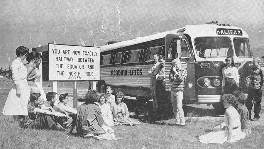
Controversy in the past over this claim stems from the fact that the Earth is not a perfect sphere, and therefore the halfway mark lies approximately 16 km North of the 45th parallel.
A short distance from downtown Stewiacke is a marker indicating the true halfway point between the Equator and the North Pole. You might think halfway point would be at the 45th N Latitude, but because the earth is spherical, it actually lies a little further north and very near Mastodon Ridge.
If you have any history information you would like posted on this site,
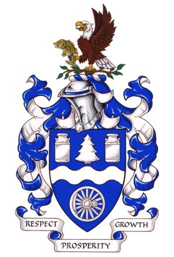
Arms of the Town of StewiackeBlazonAzure a fess wavy between in chief a pine tree flanked by two milk pails and in base a steam locomotive wheel Argent; SymbolismBlue and white are the town and provincial colours. The wavy stripe refers to the town’s name, derived from the Mi’kmaq word Esiktaweak, meaning “a place where sands move”, being a reference to the winding Stewiacke River. The pine tree symbolizes the forestry industry, and the milk pails indicate the importance of dairy farms in the local economy. The railway wheel refers to the town’s origins with its rail station established in the 1850s. |
CrestBlazonA bald eagle wings elevated and addorsed holding in the dexter claw a smallmouth bass and perched on elm branches proper; SymbolismThe eagle is a notable local bird, and the bass symbolizes sport fishing in the local rivers. The elm branches refer to the trees that were once a feature of local streets. |
MottoBlazonRESPECT • GROWTH • PROSPERITY; |
